In an effort to mitigate potential damage and speed up recovery works, the Yangon Region government is planning to set up an earthquake monitoring committee, according to official media on December 21.
The committee will be tasked with promotion of public awareness of earthquakes and development of preparedness and response plan for quakes, emergency medical preparation, restoration and reconstruction, a statement from the Social Welfare, Relief and Resettlement Department of the regional government said.
Yangon Region is just 35 km far from the Sagaing Fault, a major tectonic structure cutting through the centre of Myanmar and passes through the populous cities of Myitkyina, Sagaing, Mandalay, Pyinmana, Naypyidaw, Taungoo and Bago to ultimately drop off into the Mottama Gulf (also known as the Gulf of Martaban), widely dividing the country into a western half moving north with the Indian plate and an eastern half attached to the Eurasian plate. The latest big quake caused by the Sagaing Fault struck the Thabeikkyin area 100 km north of Mandalay in November 2012, claiming 26 lives and devastating 462 buildings.
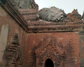
Myanmar was recently trembled by a magnitude 6.8 earthquake with the epicenter detected 25 km west of Chauk, a town in central Myanmar, destroying several heritage structures in the nearby ancient city of Bagan. The August 2016 shake ruined as many as 396 pagodas and stupas in the cultural city. Tremors from the quake were felt in Yangon, eastern Indian cities and Bangkok.
Prior to that quake, the country was also struck by a magnitude 6.9 earthquake 135 km north-east of Mandalay in mid-April that year. There was no report of major damage or loss of life as a result of that.


