Water is life and therefore rivers are the lifeline of any country. Rivers are, in fact, the arteries of our planet. The steady flow of clean, fresh water is an essential element for vast ecosystems and the health and survival of billions of people. We have used them as a source of water, for food, for transport, for recreation, as defenses, as a source of power to drive machinery, and as a means of disposing of waste. Rivers continue to be a very important source of food for societies around the world. Apart from being a rich source of fish, rivers indirectly aid in cultivation with its supply of water for the crops. Unfortunately, large dams are being constructed on all of Myanmar’s major rivers and tributaries by Chinese, Thai and Indian companies. The dams are causing displacement, militarization, human rights abuses, and irreversible environmental damage. These and couple of other factors are threatening the livelihoods and food security of millions.
Irrawaddy/Ayeyarwady River
Myanmar’s most important commercial waterway is Irrawaddy River which is the principal river of Myanmar, running through the centre of the country. Irrawaddy River had stirred the imagination of some of the world’s greatest writers, such as Kipling and Orwell. Some say “Irrawaddy” is an English corruption of Ayerawaddy Myit, which some scholars translate as “river that brings blessings to the people.” But the name is also believed to derive from the Sanskrit term airāvatī, meaning “Elephant River.” It is about 1,350 miles (2,170 km) long. The river flows wholly within the territory of Myanmar. Its total drainage area is about 158,700 square miles (411,000 square km). Its valley forms the historical, cultural, and economic heartland of Myanmar.
The river was used for trade and transport as early as the sixth century. By the twelfth century, a well-developed network of canals made for flourishing rice cultivation. Later, the river became a key economic tool of Imperial British interests, who set up trading ports along its shores The river is still vital today as a considerable amount of (export) goods and traffic moves by river. Having developed an extensive network of irrigation canals, the river became important to the British Empire after it had colonized Myanmar. Rice is produced in the Irrawaddy Delta, irrigated by water from the river.
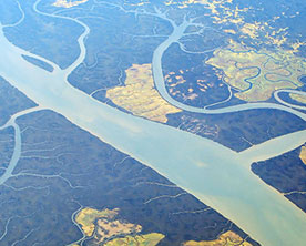
Due to monsoonal rains, which occur between mid-May and mid-October, the volume of the Irrawaddy and its tributaries varies greatly throughout the year. In summer, the melting of snow and glaciers in Northern Myanmar add to the volume. The Irrawaddy River and its tributaries flow into the Andaman Sea through the Irrawaddy Delta. This eco region consists of mangroves and freshwater swamp forests. It is an extremely fertile area because of the river-borne silt deposited in the delta. The upper and central portions of the delta are almost entirely under cultivation, principally for rice. Environmental organisations have raised concerns about the ecological impacts on the river’s bio-diverse ecosystems. Animals potentially impacted include the threatened Irrawaddy dolphin and the Irrawady river shark, an endangered species.
Chindwin River
The largest tributary of the Irrawaddy River, Chindwin River flows entirely within Myanmar. The Chindwin originates in the broad Hukawng Valley of Kachin State of Myanmar, where the Tanai, the Tabye, the Tawan, and the Taron rivers meet. Much of Chindwin’s course lies within mountain ranges and forests. The mountain ranges to the west of the Chindwin are formidable, yet not totally impregnable to armies. The Kabaw valley saw many invasions by the kingdom of Manipur most notably during the reign of King Garibaniwaj (1709–1748) when his army crossed over the Chindwin. River Chindwin was a major barrier both for the Japanese trying to invade India and for the Allied forces to reoccupy Burma. Teak forests within its drainage area have been a valuable resource since ancient times. The Hukawng Valley is known for its abundance of amber. Along the river, there are deposits of jade, as well.
Salween River
Salween River (known as the Nu in China and the Thanlwin in Burma) is powerful and undammed, and one of the longest free-flowing rivers in the world. It is about 2,815 kilometres (1,749 mi) long, that flows from the Tibetan Plateau into the Andaman Sea in Southeast Asia. It drains a narrow and mountainous watershed of 324,000 square kilometres (125,000 sq mi) that extends into the countries of China, Burma and Thailand. The river has served as the only connection between villages in the region for thousands of years. Although not navigable by larger craft such as barges or ferries, the river was widely used for transportation by small boats, because the rugged surrounding terrain had no major roads or paths.
Wild and picturesque in its upper reaches the Salween flows through narrow, deep gorges. It cuts through the Shan Plateau of Myanmar. It is crossed by the Burma Road (Huiting Bridge) and by several road ferries in the Shan region. At Moulmein the Salween forms a small alluvial delta with the Gyaing and Ataran rivers.
The Salween basin is one of the largest in Southeast Asia. It is approximately 324,000 square kilometres (125,000 sq mi) large, spreading across three countries and four Myanmar states. One of the most diverse eco regions in the world is supported by the Salween drainage basin.The river supports up 140 species of fish. According to UNESCO, the upper regions of the Salween in China, where it runs parallel to the Mekong and Yangtze rivers, “may be the most biologically diverse temperate ecosystem in the world”. The Salween River flows through the following two protected areas Salawin National Park and Salawin Wildlife Sanctuary, both are in Thailand.
Sittaung River
Sittaung River lies in east-central Myanmar. The river is navigable for 40 km year round and for 90 km during three months of the year. The broad Sittaung River valley lies between the forested Bago Mountains on the west and the steep Shan Plateau on the east and holds the main road and railway from Yangon (Rangoon) to Mandalay as well as the major towns of Bago, Taungoo, Yamethin, and Pyinmana. The river is used primarily to float timber particularly teak, for export. Strong currents make the river even less valuable as a means of transport in eastern Myanmar. Its basin does not have the same richness for agriculture as the Irrawaddy because there is no soil flowing down from the mountains.


